Today Megan and I took a nice drive out to Mt. Hamilton which sits above and to the East of San Jose. A long and very twisted roads leads you out of San Jose and will eventually take you right to the top of the mountain.
I may as well add here that my intention in this goal was not to hike to highest point in all counties, just get there. There will be plenty of tough hikes and climbs regardless since, for the most part, no roads lead to the top the summits.
Anyways, beautiful winters day, and we could see quite far in all directions. On the top of the mountain you will find the James Lick observatory, which at one point claimed to have the world's most powerful reflector telescope. Oddly enough, he was entombed below the room housing the telescope. So currently it's the only observatory in the world that has a corpse resting beneath it. Clip of the telescope:
What's amazing is how clearly we could see the high Sierra to the East running North and South for hundreds of miles. It doesn't come out in the pictures because of the distance.
It was a cool clear winter day so I figured it would be a good day to revisit Mt. Diablo which can be scorching hot for much of the year. For this trip I had my good friend Marc and his dog Nugget to keep me company. I decided to re-do a loop I had previously done with my wife Megan, because it circumnavigates the mountain so you get a new view over each ridge. You can find more details for this specific trail here: Link to trail description
The description lists the hike as being 4 hours, but keeping a good clip I've been able to do it in under 3 both times I've done it.
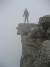
One of the great things about this mountain is despite it's relatively low elevation, you can see for great distances on all sides. It really sticks up above the surrounding countryside. This is especially true to the east, where on this day, we were able to clearly see the snow capped Sierras for hundreds of miles both North and South. We could also clearly see quite a few other county high points from this spot including: Mt. Tamalpais, Mt. Davidson, Mt. Hamilton, Mt. Vaca, South Butte, Discovery Peak, and possibly the high points in Napa and Sonoma counties, but I'm not certain of that yet. While the view East is grand and spectacular in terms of scale, the view to the West is no less amazing. You can see most of the bay area, and on a clear day, see San Francisco and the Golden Gate bridge shining in the west.
It turned out to be a very pleasant hike, and I have to say, despite her diminutive size, Nugget is an excellent hiker. She must have amazing energy reserves to keep her small legs pumping at such a rapid pace over 6 1/2 miles.
The road which leads to the summit is hugely popular with bicyclists so you can expect to see many of them on the summit and the road. But once off on the trail, we were pretty much alone except for the occasional hiker. We saw maybe six other hikers in total.
The soil was nicely damp and the vegetation had turned green from the recent rains and snow. A week beforehand the top of the mountain had reportedly gotten 4 inches of snow in an exceptionally cold winter storm. While dustings are common on this mountain, 4 inches is rare. All in all a very nice climb which is close to home for me, and a terrific view. A nice way to start off my reports.
Here is a short video of a 360 degree summit panorama which starts by looking west.

 Link to photo set.