Friday, June 5, 2009

Mt. Shasta - Siskiyou County


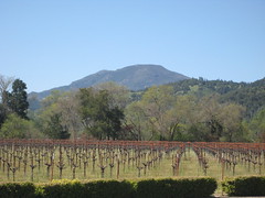
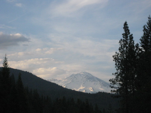
At 14,179ft. Mt. Shasta towers above the surrounding region, a lone stratovolcano covered in snow and ice for much of the year. It's the 4th highest county high point, but is a mere 350ft shorter than Mt. Whitney. As you drive North through California's great San Joaquin valley you'll eventually see Shasta dominating the Northern head of the valley, and is visible from two hours away on a clear day.

This was my 3rd summit of Mt. Shasta, it being a great mountain for a beginning mountaineer. The approach is fairly short and easy, but also very challenging, rising 7,500ft. from the parking lot via the Avalanche Gulch route, which is the standard route on the mountain.


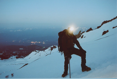
A typical climb via this route entails: Climbing from the parking lot at 6900ft. to Helen Lake at 10,600ft. the first morning. It's best to do this early when the snow conditions are better at supporting the weight of the heavy packs you're pulling up the mountain at this point. This portion usually takes anywhere from 5 - 7 hours depending on your fitness and pace. The rest of the afternoon involves making camp, making water, and trying to rest. Early the next morning (typically around 3 - 4am for me) we would leave for the summit and hopefully arrive at the summit around 9am. It averages around 5 1/2 hours for most.

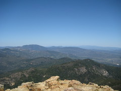
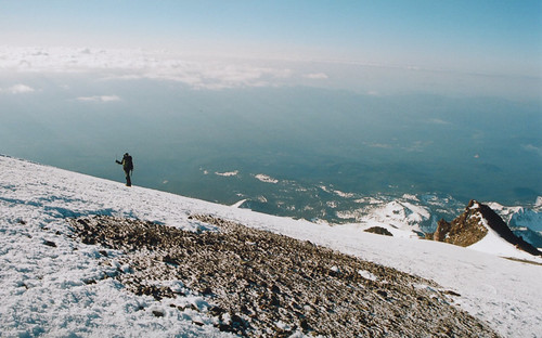
The climb is spectacular as soon as the sun comes out as you feel like your are towering above the surrounding area. The trickiest and steepest part of the climb involves climbing through some chutes of red volcanic rock call the Red Banks, but it's not really too difficult or hairy unless you're scared of heights.


For this particular trip I went up with my cousin Chris and the conditions could not have been nicer despite the brief hailstorm caused by passing late afternoon thunderheads. After the climb Chris had the typical reaction after being introduced to mountaineering: "I had a blast, it was amazing, a real challange, really hard, and I probably never want to do it again." I'm glad we were able to summit on his first attempt, which is not an easy feat.

A link to the Flickr slideshow

Monday, April 6, 2009

Mt. Saint Helena - Napa County


View Larger Map

Mt. Saint Helena, not to be confused with Mt. Saint Helens the volcano in Washington state, is a peak with a wide broad prominence that sits at the northern head of the lush Napa valley. Below is a picture of the peak taken from the lovely grounds of Clos Pegase winery in Calistoga.

IMG_0659

The drive up through the Napa valley on a cool spring morning was fairly magical. Tall Redwoods and Oaks mingled quite naturally on hillsides and glowed a warm green, still freshly nourished by rain. Four million dollar an acre vineyards flattened out the narrow valley which terminates at the foot of Mt. Saint Helena where the town of Calistoga manages to retain somehow it's quaintness and realism despite the money and yuppies on hogs rolling into it's streets.

A short climb on a crowded twisty road brought us to the trailhead parking lot. The 2,000ft elevation gain over 5 miles turned out to be a fairly easy go up a gentle grade most of the way. The views were pretty spectacular from the top where we could easily see Mt. Lassen to the north east which unfortunately doesn't come out in the pictures I took, all of which you can see here:

Link to Flicker Set

IMG_0647

Sunday, January 11, 2009

Mt. Hamilton - Santa Clara County


Today Megan and I took a nice drive out to Mt. Hamilton which sits above and to the East of San Jose. A long and very twisted roads leads you out of San Jose and will eventually take you right to the top of the mountain.

I may as well add here that my intention in this goal was not to hike to highest point in all counties, just get there. There will be plenty of tough hikes and climbs regardless since, for the most part, no roads lead to the top the summits.

Anyways, beautiful winters day, and we could see quite far in all directions. On the top of the mountain you will find the James Lick observatory, which at one point claimed to have the world's most powerful reflector telescope. Oddly enough, he was entombed below the room housing the telescope. So currently it's the only observatory in the world that has a corpse resting beneath it. Clip of the telescope:


What's amazing is how clearly we could see the high Sierra to the East running North and South
for hundreds of miles. It doesn't come out in the pictures because of the distance.


Link to photo set.

Mt. Diablo - Contra Costa County


It was a cool clear winter day so I figured it would be a good day to revisit Mt. Diablo which can be scorching hot for much of the year. For this trip I had my good friend Marc and his dog Nugget to keep me company. I decided to re-do a loop I had previously done with my wife Megan, because it circumnavigates the mountain so you get a new view over each ridge. You can find more details for this specific trail here:

Link to trail description


The description lists the hike as being 4 hours, but keeping a good clip I've been able to do it in under 3 both times I've done it.

One of the great things about this mountain is despite it's relatively low elevation, you can see for great distances on all sides. It really sticks up above the surrounding countryside. This is especially true to the east, where on this day, we were able to clearly see the snow capped Sierras for hundreds of miles both North and South. We could also clearly see quite a few other county high points from this spot including: Mt. Tamalpais, Mt. Davidson, Mt. Hamilton, Mt. Vaca, South Butte, Discovery Peak, and possibly the high points in Napa and Sonoma counties, but I'm not certain of that yet. While the view East is grand and spectacular in terms of scale, the view to the West is no less amazing. You can see most of the bay area, and on a clear day, see San Francisco and the Golden Gate bridge shining in the west.

Here is a link to the photoset.


It turned out to be a very pleasant hike, and I have to say, despite her diminutive size, Nugget is an excellent hiker. She must have amazing energy reserves to keep her small legs pumping at such a rapid pace over 6 1/2 miles.

The road which leads to the summit is hugely popular with bicyclists so you can expect to see many of them on the summit and the road. But once off on the trail, we were pretty much alone except for the occasional hiker. We saw maybe six other hikers in total.

The soil was nicely damp and the vegetation had turned green from the recent rains and snow. A week beforehand the top of the mountain had reportedly gotten 4 inches of snow in an exceptionally cold winter storm. While dustings are common on this mountain, 4 inches is rare. All in all a very nice climb which is close to home for me, and a terrific view. A nice way to start off my reports.

Here is a short video of a 360 degree summit panorama which starts by looking west.

Monday, December 15, 2008

The Goal: To reach the highest point in each of California's 58 Counties


Today I had a thought: I will try to reach the top of each of California's 58 counties.

Some are easy, some are hard. Carpenter Hill in Sacramento county is just an 828 foot hill. Mt. Whitney, in Inyo County, is 13,677 ft. higher. Some are easy to get to, some appear to be quite difficult to reach. I have already been to the top of several, some more notable then others. But I would like to revisit even the ones I have already been to, so that I may document it for my own amusement, and perhaps, the amusement of others.

58 Peaks is actually not quite accurate I must admit. Mt Whitney is the highest point in two counties, as is Snow Mountain East. So really it's more like 56.

One thing that intrigues me about this is not only the challenge, but the variety that I will no doubt encounter. From Coastal ranges to the deserts and high peaks of the Sierra Nevada. The densely forested mountains of the north coast, the snowy Cascades, and the city of San Francisco.

Some seem a bit daunting, most notably North Palisade. Although I'm an aspiring mountaineer, my skills will have to be bettered before taking on it's technical sections.

This will take a fair amount of time for sure, but I think quite doable as long as I'm committed. I'm hoping to finish this before I turn 40, which gives me about 12 years.

List of peaks below sorted by elevation and with links to Wikipedia info:

County Name Height
feet / m

Inyo Mount Whitney 14,505 / 4,421
Tulare Mount Whitney 14,505 / 4,421
Mono White Mountain Peak 14,246 / 4,342
Fresno North Palisade 14,242 / 4,341
Siskiyou Mount Shasta 14,162 / 4,317
Madera Mount Ritter 13,143 / 4,006
Tuolumne Mount Lyell 13,114 / 3,997
Mariposa Parsons Peak Ridge 12,040+ / 3,670+
San Bernardino San Gorgonio Mountain (Old Grayback) 11,499 / 3,505
Alpine Sonora Peak 11,459 / 3,493
El Dorado Freel Peak 10,881 / 3,317
Riverside San Jacinto Peak 10,804 / 3,293
Shasta Lassen Peak 10,457 / 3,187
Los Angeles Mount San Antonio (Mt. Baldy) 10,064 / 3,068
Modoc Eagle Peak 9,892 / 3,015
Amador Thunder Mountain 9,410 / 2,868
Tehama Brokeoff Mountain 9,235 / 2,815
Nevada Mount Lola 9,148 / 2,788
Trinity Mount Eddy 9,025 / 2,751
Placer Granite Chief 9,006 / 2,745
Sierra Mount Lola North 8,844 / 2,696
Ventura Mount Pinos 8,831 / 2,692
Kern Sawmill Mountain 8,818 / 2,688
Lassen Hat Mountain 8,737 / 2,663
Plumas Mount Ingalls 8,372 / 2,552
Calaveras Corral Ridge 8,170 / 2,490
Glenn Black Butte 7,448 / 2,270
Butte Lost Lake Ridge 7,120+ / 2,170+
Lake Snow Mountain East 7,056 / 2,151
Colusa Snow Mountain East 7,040+ / 2,146+
Humboldt Salmon Mountain 6,956 / 2,120
Mendocino Anthony Peak 6,954 / 2,120
Santa Barbara Big Pine Mountain 6,820 / 2,073+
San Diego Hot Springs Mountain 6,533 / 1,991
Del Norte Bear Mountain 6,400+ / 1,951+
Monterey Junipero Serra Peak 5,862 / 1,787
Orange Santiago Peak (part of the Saddleback) 5,687 / 1,733
San Benito San Benito Mountain 5,241 / 1,597
San Luis Obispo Caliente Mountain 5,106 / 1,556
Yuba Sugar Pine Peak 4,825+ / 1,471+
Imperial Blue Angels Peak 4,548 / 1,386
Sonoma Cobb Mountain West Rim 4,480+ / 1,366+
Santa Clara Copernicus Peak 4,360+ / 1,329+
Napa Mt. St. Helena East 4,200+ / 1,280+
Contra Costa Mount Diablo 3,849 / 1,173
Alameda Discovery Peak 3,840+ / 1,170+
Stanislaus Mount Stakes 3,804 / 1,159
Merced Laveaga Peak 3,801 / 1,159
San Joaquin Mt. Boardman North 3,626 / 1,105
Kings Table Mountain 3,473 / 1,059
Santa Cruz Mount McPherson 3,231 / 985
Yolo Little Blue Peak 3,120+ / 951
Solano Mount Vaca 2,819 / 859
San Mateo Long Ridge 2,600+ / 792+
Marin Mount Tamalpais 2,571 / 784
Sutter South Butte 2,120+ / 646+
San Francisco Mount Davidson 927 / 283
Sacramento Carpenter Hill 828 / 252